How to prepare a GPX for a trip or race
Before the trip, it is useful to open the track on the big screen and make sure that this is the right version of the route. The FATRACING editor allows you to view the file, set the name of the card, save the link and download GPX.
1. Take the current file
For the race, download GPX from the last message or page of the organizer and check the distance. An old file with a similar name may contain last year's track. Save the source code separately to be able to return to it.
Open it GPX editor and select the file. A track or route with coordinates of at least two points is supported; the file size is limited to 20 MB. The ZIP archive, the screenshot of the map and the FIT must first be prepared in a suitable tool.
2. Inspect the track as a whole and by sections
After selecting the file, the line on the map, the distance, the number of points and the original name of the GPX are displayed. The first point is marked in green, the last one in red; they can overlap at a closed track.
Increase the starting area, forks, and finish. See if there is a direct jump across the entire area or a missing section. The editor connects the read points with a line; a gap between segments can also look like a connection. Such a line does not prove the presence of a road.
The map does not confirm the carriageway, access to private territory, or the condition of bridges. For the race, follow the current instructions of the organizer, for an independent route, check the questionable sections separately.
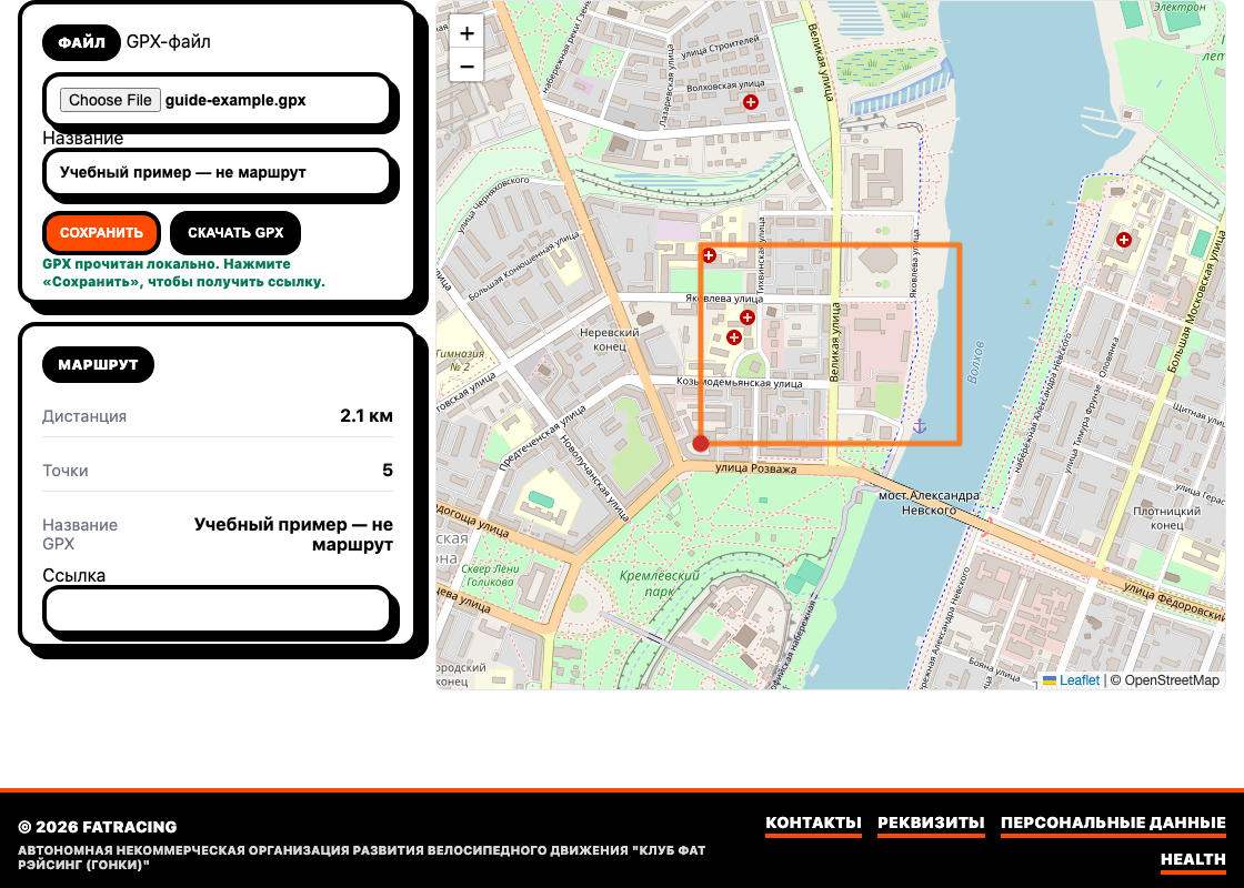
3. Consider the capabilities of the editor
Right now, there is no drawing a new path, moving points and trimming the beginning or end. If the file needs to be changed geometrically, do it in the route editor with the appropriate functions and upload the result again.
Renaming on the page sets the name of the card and the name of the file to download. The embedded name inside the original GPX will not necessarily change from this: the navigator can continue to show the old name. The coordinates of the downloaded track remain the same.
4. Save the link if you want to share
Selecting a file reads GPX locally in the browser. The "Save" button sends it to the server and creates a link. Wait for the message "Saved. The link can be shared" and the appearance of the address in the "Link" field. Check it in a new tab.
The link should be considered access to the route, not private storage: the content can be accessed at the address, and the editor by token allows you to update the record. Before saving, remove sensitive points, such as an accurate home start, in another tool. The absence of a page in the search does not restrict access by link.
To create a separate version, start with an empty address The editor. Working in an already open saved record can update it using the previous link.
5. Download and check on yandex. navigator
Click "Download GPX" and import the file in a way that your bike computer or application supports. Then check the name, length, start and finish already on the device. The presence of a file in the downloads folder does not mean that navigation is ready.
Open the route and the required offline maps in advance. If the device recalculates the path along the roads, compare it with the original track: the recalculation may lead differently. Save the latest version and contact the organizer before check-out.